نهر النيل هذا النهر العظيم الذي يمتد داخل إفريقيا كامتداد الشريان في الجسد ، والذي شاهد ميلاد حضارات عظيمة مثلما شاهد انهيار حضارات أخرى قوية ، فكثيراً ما أفاض علينا بالخير، وهب الحياة وأنبت الزرع وأضاء الميادين والمدن.
ممتد فينا إلى أن يرث الله الأرض ومن عليها
يضم "النيل" على امتداده (10) دول إفريقية تعاني معظمها من الحروب الداخلية والحروب فيما بينها، مما جعل هذه الدول في ذيل الاقتصاد العالمي تجرها قاطرات الفقر والعصبية.
من هنا جاءت فكرتنا لتكون المصلحة واحدة والهدف واحد مثلما يجمعنا نيل واحد، وحتى يتثنى لنا تحقيق الهدف يجب أولاً معرفة أنفسنا، فنحن في حاجة ماسة لمعرفة بعضنا البعض، فطول النيل يجعلنا نتباعد ونختلف في العادات والتقاليد واللغات. وليكن الموضوع التالي أولى خطواتنا في تحقيق الهدف وتنمية المعرفة.
يبلغ طول نهر النيل 6825 كم وتبلغ مساحة حوضه (3) ملايين كم2 . وينبع النيل من مصدرين رئيسيين هما إقليم البحيرات الاستوائية جنوب السودان والهضبة الإثيوبية . كما تضع المنابع الاستوائية المجاري النهرية والبحيرات التي تقع في هضبة البحيرات وتتكون من بحيرة فيكتوريا والتي تضم حوض بحيرة فيكتوريا وحوض بحيرة كيوجام إلى جانب المجموعة الألبرتية والتي تضم حوض بحيرتي جورج وإدوارد وحوض نهر السمليكي الذي يصل بين بحيرتي إدوارد وألبرت وحوض بحيرة ألبرت التي يخرج منها نيل ألبرت.
أما المنابع الإثيوبية فتشمل ثلاثة روافد هم نهر السوباط والنيل الأزرق ونهر العطبرة وتعتبر الهضبة الإثيوبية أهم منابع النيل إذ تمد النيل الرئيسي عند أسوان بـ (85%) من متوسط الإيراد السنوي.
وفي مشهد رائع الجمال والإبداع الإلهي يلتقي النيل الأبيض الذي ينبع من البحيرات الاستوائية بالنيل الأزرق الذي ينبع من المرتفعات الإثيوبية في العاصمة السودانية "الخرطوم" والتي اختارها الله دون باقي دول حوض النيل لكي تمتلك هذا الملتقى ليجري النهر إلى سد أسوان فالبحر المتوسط.
ويغطي النيل عُشر مساحة إفريقيا ، وتقع معظم هذه المساحة خارج حدود السودان، فمعظم أجزاء النيل الأزرق وعطبرة والسوباط والنيل الأبيض في إثيوبيا والبحيرات الاستوائية.
وتتكون الدول المشاركة في حوض النهر من عشر دول هي : مصر – السودان – إثيوبيا – كينيا – بوروندي – رواندا – تنزانيا – أوغندا – الكونغو – إريتريا.
*دول الحوض في سطور
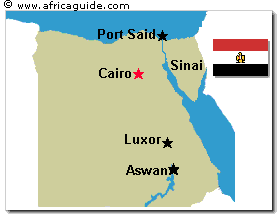
مصر :
تقع مصر في شمال إفريقيا وتعتبر دولة المصب وتحدها من الجنوب "السودان" ومن الشرق البحر الأحمر وخليج السويس ومن الغرب "ليبيا" وتبلغ مساحة "مصر" حوالي مليون كم2 وعاصمتها "القاهرة" وأهم مدنها الإسكندرية – الإسماعيلية – المنصورة – بورسعيد – أسوان – وتنقسم إلى (26) محافظة (14) في الوجه البحري ، (7) في الوجه القبلي ، (5) للحدود. وتعتبر اللغة العربية هي اللغة الأساسية للشعب المصري بجانب الإنجليزية والفرنسية. ويرجع تاريخ استقلال "مصر" إلى (1922) وتأكد بموجب معاهدة (1936) وتم الجلاء الإنجليزي نهائياً في (1956).
أما العملة المصرية فهي الجنيه المصري والذي يعادل حالياً 1/6 دولار أمريكي . أما أهم المشروعات المصرية المقامة على النيل فهي :
-القناطر الخيرية والتي تم بناؤها في نهاية الأربعينات من القرن الماضي على بعد 30) كم جنوب القاهرة العاصمة للتحكم في مياه النهر.
وهناك أيضاً خزان أسوان ويعد من أعظم التوسعات في عمليات الري المستديم وتم بناؤه في عام 1902 بسعة قدرها (مليار م3) وتقرر تعليته مرتين في (1912) ، (1933) لتصبح سعته (5.2 مليار م3) ليواكب التوسع في زيادة المحاصيل الزراعية. والمشروع الثالث هو "قناطر زفتى وإسنا ونجح حمادي" والتي بنيت في (1903) ، (1909) ، (1930) وذلك للاستفادة من مياه خزان أسوان . ويأتي "السد العالي" أهم المشاريع المصرية على النيل فقد بدأ في بنائه في (1960) وانتهى العمل به عام (1970) ويبلغ ارتفاع السد (196م) (1111م) من منسوب القاع، (85) فوق سطح البحر ، وأعلى منسوب لحجز المياه أمامه 182م حيث تكون هذه المياه المحجوزة بحيرة "ناصر" التي يبلغ طولها (500 كم) ومتوسط عرضها (12) كم ويبلغ سطحها نحو (6500) كم2 وتبلغ سعة حوض التخزين (162) مليار م3 كما تبلغ الطاقة الكهربائية المولدة من السد حوالي 10 مليارات كيلووات/ ساعة وتأتي الزراعة في المرتبة الأولى من النشاط الاقتصادي بنحو (21%) من الدخل مثل القطن – الأرز – القمح – السمسم. وأهم الصناعات الغزل والنسيج والملابس والهندسية والأسمنت ، وأهم المعادن البترول – المنجنيز – الفوسفات – الحديد.
السودان:
وتأتي السودان بعد مصر مباشرة في مصب النيل، حيث يحدها من الشمال "مصر" ومن الشرق "إثيوبيا" ومن الغرب "تشاد" ومن الجنوب "أوغندا" وتبلغ مساحة السودان 2.5 مليون كم2 حيث تشكل حوالي (8.3%) من المساحة الإجمالية للقارة الإفريقية، عاصمتها "الخرطوم" وأهم مدنها : بورسودان – أم درمان – كسلا – سنار – الأبيض ، ويرجع تاريخ استقلالها إلى (1956) واللغة العربية هي اللغة لرسمية وتتنوع اللغات في جنوب السودان تبعاً لتنوع القبائل ، عدد السكان 38.5 مليون نسمة . أما العملة السودانية فهي الجنيه السوداني والذي تحول الآن إلى الدينار السوداني الذي يساوي (10) جنيهات ، والدولار الأمريكي يعادل (2.6) دينار سوداني تقريباً.
الوضع الاقتصادي للسودان
السودان بلد زراعي ويتصدر دول العالم في إنتاج الصمغ العربي (93% من إجمالي الناتج العالمي) بالإضافة إلى زراعة القطن والقصب والأرز والتبغ والبن والفول السوداني والبنجر والموز والمانجو ، وتبلغ الأراضي القابلة للزراعة في السودان 200 مليون فدان.
كما يمتلك السودان عشرات الملايين من الماشية والماعز والأغنام، وتم اكتشاف الذهب والبترول بوفرة بجانب الحديد والفضة والنيكل والنحاس والزنك وغاز النترون.
أما الصناعة معتمدة على منتجات القطن وصناعات الزيوت والصابون والألبان والجلود وتكرير السكر.
المشاريع السودانية على النيل
*خزان سنار: الذي أنشئ عام 1925 على النيل الأزرق بغرض زراعة القطن في أراضي الجزيرة بالسودان ، خزان جبل الأولياء : أنشئ عام 1937 على النيل الأبيض بغرض تخزين ملياري متر3 لتكملة الري الصيفي لمصر حيث يحجز 3 مليارات م3 يتبخر منها مليار ، وبعد إنشاء السد العالي بمصر سلمته الحكومة المصرية إلى حكومة السودان وأصبح تابع لها ، المشروع الثالث هو خزان الروصيرص : أنشئ عام 1964 لتخزين (3 مليارات م3) على أن يتم تعليته لاستيعاب (7) مليارات م3 طبقاً لاتفاقية 1959 المنظمة لمياه النيل بين مصر والسودان ، وقد موَّل هذا المشروع البنك الدولي للإنشاء والتعمير وحكومة ألمانيا الغربية بمبلغ 18 مليون جنيه.
ويأتي خزان خشم القربة : الذي أُنشئ على نهر عطبرة عام 1964 لتخزين 1.2 مليار م3 لري أراضي حلفا الجديدة التي هاجر إليها سكانها من حلفا القديمة مع بداية العمل في السد العالي ، بالإضافة إلى توليد طاقة كهربائية تقدر بحوالي (7) آلاف كيلووات/ساعة.
ممتد فينا إلى أن يرث الله الأرض ومن عليها
يضم "النيل" على امتداده (10) دول إفريقية تعاني معظمها من الحروب الداخلية والحروب فيما بينها، مما جعل هذه الدول في ذيل الاقتصاد العالمي تجرها قاطرات الفقر والعصبية.
من هنا جاءت فكرتنا لتكون المصلحة واحدة والهدف واحد مثلما يجمعنا نيل واحد، وحتى يتثنى لنا تحقيق الهدف يجب أولاً معرفة أنفسنا، فنحن في حاجة ماسة لمعرفة بعضنا البعض، فطول النيل يجعلنا نتباعد ونختلف في العادات والتقاليد واللغات. وليكن الموضوع التالي أولى خطواتنا في تحقيق الهدف وتنمية المعرفة.
يبلغ طول نهر النيل 6825 كم وتبلغ مساحة حوضه (3) ملايين كم2 . وينبع النيل من مصدرين رئيسيين هما إقليم البحيرات الاستوائية جنوب السودان والهضبة الإثيوبية . كما تضع المنابع الاستوائية المجاري النهرية والبحيرات التي تقع في هضبة البحيرات وتتكون من بحيرة فيكتوريا والتي تضم حوض بحيرة فيكتوريا وحوض بحيرة كيوجام إلى جانب المجموعة الألبرتية والتي تضم حوض بحيرتي جورج وإدوارد وحوض نهر السمليكي الذي يصل بين بحيرتي إدوارد وألبرت وحوض بحيرة ألبرت التي يخرج منها نيل ألبرت.
أما المنابع الإثيوبية فتشمل ثلاثة روافد هم نهر السوباط والنيل الأزرق ونهر العطبرة وتعتبر الهضبة الإثيوبية أهم منابع النيل إذ تمد النيل الرئيسي عند أسوان بـ (85%) من متوسط الإيراد السنوي.
وفي مشهد رائع الجمال والإبداع الإلهي يلتقي النيل الأبيض الذي ينبع من البحيرات الاستوائية بالنيل الأزرق الذي ينبع من المرتفعات الإثيوبية في العاصمة السودانية "الخرطوم" والتي اختارها الله دون باقي دول حوض النيل لكي تمتلك هذا الملتقى ليجري النهر إلى سد أسوان فالبحر المتوسط.
ويغطي النيل عُشر مساحة إفريقيا ، وتقع معظم هذه المساحة خارج حدود السودان، فمعظم أجزاء النيل الأزرق وعطبرة والسوباط والنيل الأبيض في إثيوبيا والبحيرات الاستوائية.
وتتكون الدول المشاركة في حوض النهر من عشر دول هي : مصر – السودان – إثيوبيا – كينيا – بوروندي – رواندا – تنزانيا – أوغندا – الكونغو – إريتريا.
*دول الحوض في سطور
مصر :
تقع مصر في شمال إفريقيا وتعتبر دولة المصب وتحدها من الجنوب "السودان" ومن الشرق البحر الأحمر وخليج السويس ومن الغرب "ليبيا" وتبلغ مساحة "مصر" حوالي مليون كم2 وعاصمتها "القاهرة" وأهم مدنها الإسكندرية – الإسماعيلية – المنصورة – بورسعيد – أسوان – وتنقسم إلى (26) محافظة (14) في الوجه البحري ، (7) في الوجه القبلي ، (5) للحدود. وتعتبر اللغة العربية هي اللغة الأساسية للشعب المصري بجانب الإنجليزية والفرنسية. ويرجع تاريخ استقلال "مصر" إلى (1922) وتأكد بموجب معاهدة (1936) وتم الجلاء الإنجليزي نهائياً في (1956).
أما العملة المصرية فهي الجنيه المصري والذي يعادل حالياً 1/6 دولار أمريكي . أما أهم المشروعات المصرية المقامة على النيل فهي :
-القناطر الخيرية والتي تم بناؤها في نهاية الأربعينات من القرن الماضي على بعد 30) كم جنوب القاهرة العاصمة للتحكم في مياه النهر.
وهناك أيضاً خزان أسوان ويعد من أعظم التوسعات في عمليات الري المستديم وتم بناؤه في عام 1902 بسعة قدرها (مليار م3) وتقرر تعليته مرتين في (1912) ، (1933) لتصبح سعته (5.2 مليار م3) ليواكب التوسع في زيادة المحاصيل الزراعية. والمشروع الثالث هو "قناطر زفتى وإسنا ونجح حمادي" والتي بنيت في (1903) ، (1909) ، (1930) وذلك للاستفادة من مياه خزان أسوان . ويأتي "السد العالي" أهم المشاريع المصرية على النيل فقد بدأ في بنائه في (1960) وانتهى العمل به عام (1970) ويبلغ ارتفاع السد (196م) (1111م) من منسوب القاع، (85) فوق سطح البحر ، وأعلى منسوب لحجز المياه أمامه 182م حيث تكون هذه المياه المحجوزة بحيرة "ناصر" التي يبلغ طولها (500 كم) ومتوسط عرضها (12) كم ويبلغ سطحها نحو (6500) كم2 وتبلغ سعة حوض التخزين (162) مليار م3 كما تبلغ الطاقة الكهربائية المولدة من السد حوالي 10 مليارات كيلووات/ ساعة وتأتي الزراعة في المرتبة الأولى من النشاط الاقتصادي بنحو (21%) من الدخل مثل القطن – الأرز – القمح – السمسم. وأهم الصناعات الغزل والنسيج والملابس والهندسية والأسمنت ، وأهم المعادن البترول – المنجنيز – الفوسفات – الحديد.
السودان:
وتأتي السودان بعد مصر مباشرة في مصب النيل، حيث يحدها من الشمال "مصر" ومن الشرق "إثيوبيا" ومن الغرب "تشاد" ومن الجنوب "أوغندا" وتبلغ مساحة السودان 2.5 مليون كم2 حيث تشكل حوالي (8.3%) من المساحة الإجمالية للقارة الإفريقية، عاصمتها "الخرطوم" وأهم مدنها : بورسودان – أم درمان – كسلا – سنار – الأبيض ، ويرجع تاريخ استقلالها إلى (1956) واللغة العربية هي اللغة لرسمية وتتنوع اللغات في جنوب السودان تبعاً لتنوع القبائل ، عدد السكان 38.5 مليون نسمة . أما العملة السودانية فهي الجنيه السوداني والذي تحول الآن إلى الدينار السوداني الذي يساوي (10) جنيهات ، والدولار الأمريكي يعادل (2.6) دينار سوداني تقريباً.
الوضع الاقتصادي للسودان
السودان بلد زراعي ويتصدر دول العالم في إنتاج الصمغ العربي (93% من إجمالي الناتج العالمي) بالإضافة إلى زراعة القطن والقصب والأرز والتبغ والبن والفول السوداني والبنجر والموز والمانجو ، وتبلغ الأراضي القابلة للزراعة في السودان 200 مليون فدان.
كما يمتلك السودان عشرات الملايين من الماشية والماعز والأغنام، وتم اكتشاف الذهب والبترول بوفرة بجانب الحديد والفضة والنيكل والنحاس والزنك وغاز النترون.
أما الصناعة معتمدة على منتجات القطن وصناعات الزيوت والصابون والألبان والجلود وتكرير السكر.
المشاريع السودانية على النيل
*خزان سنار: الذي أنشئ عام 1925 على النيل الأزرق بغرض زراعة القطن في أراضي الجزيرة بالسودان ، خزان جبل الأولياء : أنشئ عام 1937 على النيل الأبيض بغرض تخزين ملياري متر3 لتكملة الري الصيفي لمصر حيث يحجز 3 مليارات م3 يتبخر منها مليار ، وبعد إنشاء السد العالي بمصر سلمته الحكومة المصرية إلى حكومة السودان وأصبح تابع لها ، المشروع الثالث هو خزان الروصيرص : أنشئ عام 1964 لتخزين (3 مليارات م3) على أن يتم تعليته لاستيعاب (7) مليارات م3 طبقاً لاتفاقية 1959 المنظمة لمياه النيل بين مصر والسودان ، وقد موَّل هذا المشروع البنك الدولي للإنشاء والتعمير وحكومة ألمانيا الغربية بمبلغ 18 مليون جنيه.
ويأتي خزان خشم القربة : الذي أُنشئ على نهر عطبرة عام 1964 لتخزين 1.2 مليار م3 لري أراضي حلفا الجديدة التي هاجر إليها سكانها من حلفا القديمة مع بداية العمل في السد العالي ، بالإضافة إلى توليد طاقة كهربائية تقدر بحوالي (7) آلاف كيلووات/ساعة.
__________________________River Nile, this great river, which runs within Africa as an extension of the artery in the body, and who saw the birth of great civilizations, as witness the collapse of other civilizations is strong, often elaborated on us well, gave life and Spring planting and lighted fields and cities.Extended to us that God inherits the earth and them
Includes "the Nile" on the extension (10), most African countries suffer from internal wars and wars between them, making these countries at the bottom of the global economy pulled by locomotives poverty and nervousness.
From here came our idea to be of interest and one goal is the same as us together win one, and even says to us achieve the goal you must first know ourselves, we urgently need to know each other, length of the growing Nile us Ntbaeid and differ in customs, traditions and languages. The next topic was the first step in achieving the goal and the development of knowledge.
The length of the River Nile 6825 km and a drainage area (3) million km 2. Stems from two main sources of the Nile are the equatorial lakes region of Southern Sudan and the Ethiopian plateau. It also sets out the sources of Equatorial sewage river and lakes that are located in the plateau lakes consist of Lake Victoria, which includes the Lake Victoria Basin and Lake Basin Kiujam along with the group Alalbrtah, which includes the basin lakes George and Edward and River Basin Alsmlika that connects Lakes Edward and Albert and the basin of Lake Albert, which comes out of the Nile Albert.
The Ethiopian sources include three tributaries are the Sobat River and the Blue Nile and the Atbara River and the Ethiopian plateau is the most important sources of the Nile as it supplies the main Nile at Aswan B (85%) of the average annual income.
In a scene of great beauty and creativity of God meets the White Nile, which flows from Blue Nile Equatorial Lakes, which flows from the Ethiopian highlands in the capital of Sudan, "Khartoum" and chosen by God without the rest of the Nile Basin countries in order to have this forum for being the river to the sea is the Mediterranean of the Aswan Dam.
It covers the Nile tenth of Africa, and most of this space is located outside the borders of Sudan, most parts of the Blue Nile, Atbara and Sobat and White Nile in Ethiopia and the Equatorial Lakes.
It consists of participating States in the basin of the river from ten countries are: Egypt - Sudan - Ethiopia - Kenya - Burundi - Rwanda - Tanzania - Uganda - Congo - Eritrea.
* Basin countries in Brief
Egypt:
Egypt is located in North Africa and is the State of the estuary and is bordered to the south, "Sudan" and on the east the Red Sea and Gulf of Suez to the west, "Libya," The area of "Egypt" about a million km 2 and its "Cairo" and the most important cities of Alexandria - Ismailia - Mansoura - Port Said - Aswan - divided to (26) conservative (14) in the Lower, (7) in the Upper, (5) of the border. And Arabic is the primary language of the Egyptian people beside English and French. Due date of independence "Egypt" to the (1922) and make sure under the Treaty (1936) was finally evacuated in English (1956).
The Egyptian currency is the Egyptian pound, which is equivalent to 1/6 U.S. dollars. The most important Egyptian projects built on the Nile are:
- Qanater, which was built at the end of the forties of the last century at a distance of 30) kilometers south of Cairo, the capital of the control in the waters of the river.
There is also the Aswan Reservoir and is one of the greatest expansions in irrigation sustained and was built in 1902 with a capacity of (billion m 3) and decide later enlarged twice in the (1912), (1933) to become its capacity (5.2 billion m 3) to keep pace with expansion in the increase of agricultural crops. The third project is "and Esna barrages Zefta Hammadi and successfully" and built in (1903), (1909), (1930) in order to benefit from the waters of the Aswan Reservoir. The "High Dam" the most important projects the Egyptian on the Nile began to build in the (1960) and completed in (1970) The height of the dam (196 m) (1111 m) of the level of the bottom, (85) above sea level, and the highest level to hold the water in front of him 182 m where the water reserved lake "Nasser"-long (500 km) and average width (12) km and a surface of about (6500) km 2 and has a capacity of basin storage (162) billion m 3 as an electric power generated from the dam about 10 billion kilowatt / h and agriculture come in first place of economic activity by about (21%) of income such as cotton - rice - wheat - sesame. The most important industries, the textile and clothing, engineering, cement, oil and most metals - manganese - phosphate - iron.
Sudan:
The Sudan after Egypt directly in the mouth of the Nile, which bordered on the north, "Egypt" and on the east, "Ethiopia" and the West "Chad" and the south, "Uganda" The area of Sudan, 2.5 million km 2 accounting for approximately (8.3%) of the total area of the African continent, its "Khartoum" and the most important cities: Port Sudan - Omdurman - Kassala - Sinnar - white, and dates its independence to the (1956) and the Arabic language is the language of formal and diverse languages in South Sudan due to the diversity of tribes, population 38.5 million people. The currency is the Sudanese Pound Sudanese, who now turned to the Sudanese dinar, which is equal to (10) pounds, and the U.S. dollar equivalent of (2.6) Sudanese Dinar almost.
Economic situation of the Sudan
Sudan is an agricultural country leads the world in the production of gum arabic (93% of the total global output) in addition to the cultivation of cotton and sugar cane, rice, tobacco, coffee, peanuts, beets, bananas, mangoes, and the amount of arable land in Sudan, 200 million acres.
Sudan also has tens of millions of cattle, goats and sheep, was the discovery of gold and oil in abundance next to iron, silver, nickel, copper, zinc, and nitrous gas.
The industry based on products and cotton industries, oil, soap, milk, leather and sugar refining.
Sudanese projects on the Nile
* Tank Sennar: which was established in 1925 on the Blue Nile for cotton cultivation in the territory of the island, Sudan, Reservoir Mount parents was established in 1937 on the White Nile to store two billion m 3 to supplement the irrigation summer to Egypt, where he booked 3 billion m 3 evaporates billion, and after the establishment of the High Dam Egypt was handed over by the Egyptian government to the Government of Sudan and has continued her third project is the tank Roseires was established in 1964 to store (3 billion m 3) to be later enlarged to accommodate (7) billion m 3 according to the 1959 Agreement Governing the Nile water between Egypt and Sudan, has funded this project International Bank for Reconstruction and Development and the Government of West Germany's $ 18 million.
The tank Khashm Bagpipes: which was established on the Atbara River in 1964 to store 1.2 billion m 3 irrigation lands New Halfa, which migrated to the population of an alliance with the old beginning of the work in the High Dam, in addition to the generation of electrical energy is estimated at about (7) of thousands of kilowatts / hour.
__________________________
إثيوبيا
يحدها من الشرق جيبوتي والصومال ومن الشمال الغربي "السودان" ومن الجنوب كينيا.
وتبلغ مساحتها حوالي 1.223 مليون كم2 قبل استقلال إريتريا ، عاصمتها "أديس أبابا" وأهم مدنها "هرر – دمبا – جوندر –عصب" ، يتحدث الأثيوبيون اللغة "الأمهرية" إلى جانب الإنجليزية ، العملة هي "البر الأثيوبي" فالدولار الأمريكي = 2.05 بر أثيوبي.
يعمل حوالي (85%) من مجموع سكانها بالزراعة حيث تمثل 43% من الدخل القومي ويعتبر البن – القمح – الذرة – الشعير والبنجر والحبوب الزيتية من أهم المحاصيل وتوجد ملايين من الماشية والأغنام تستغل في صناعة الجلود ويعتبر الملح والبلاتنيوم والحديد والبوتاس واستخراج الذهب أهم الثروات المعدنية في إثيوبيا، وكان التركيز لوقت قريب على الصناعات الحربية .
ونسبة المسلمين 65% من عدد السكان والذين يبلغون 66.5 مليون نسمة.
إريتريا
يحدها جنوباً إثيوبيا ومن الشمال والغرب السودان والجنوب الشرقي جيبوتي ويمتد الساحل الإريتري على البحر الأحمر لمسافة 1080 كم2 وتمتلك أكثر من (100) جزيرة أبرزها جزيرة (دهلك) وأصل كلمة إريتريا يونانية تعني البحر الأحمر ، عاصمتها أسمرة ، أهم مدنها عصب، مصوع، عدى، ومساحتها حوالي 119 ألف كم2، ويرجع تاريخ استقلالها إلى 1993 ، ويتحدث الإريتريون ثمان لهجات محلية بخلاف اللغة العربية، تتمتع باكتفاء ذاتي من المواد الغذائية وثروة حيوانية حوالي (10) مليون رأس ، ومن المعادن الحديد والذهب والنحاس والمنجنيز واليورانيوم ، ونسبة المسلمين 90% من السكان وعددهم 4.5 مليون نسمة.
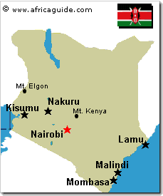
كينيا
يحدها من الشمال إثيوبيا ومن الجنوب تنزانيا ومن الشرق الصومال والمحيط الهندي ومن الغرب أوغندا ، وتبلغ مساحتها حوالي 582.647 ألف كم2 ، عاصمتها نيروبي ، أهم مدنها (الروريت – كالميا – ممبسا – كنتالي) ، يتحدث الكينيون الإنجليزية والسواحلية، ويرجع تاريخ استقلالها إلى 1963 ، وعملتها الشلن الكيني ، الدولار الأمريكي = 26 شلن ، وتحتل الزراعة النصيب الأكبر حيث يعمل بها (80%) من السكان ويمثل "البن" أهم المحاصيل والشاي جوز الهند ، القطن، قصب السكر ، القمح، الذرة ، الشعير ، الأرز، وهناك ملايين من الماشية والخراف والماعز، ويعتبر الجبس والملح والصودا والذهب أهم ثرواتها المعدنية ، وأهم صناعاتها المنسوجات والكيماويات ومعدات النقل والدخان والبترول، ويلغ عدد سكان كينيا 31.5 مليون نسمة.
رواند
تقع في وسط القارة الإفريقية وهي دولة حبيسة يحدها من الشمال أوغندا ومن الجنوب بوروندي ومن الشرق تنزانيا ومن الغرب الكونغو وسميت بلاد العشرة آلاف هضبة نظراً لطبيعتها الجبلية.
وتبلغ مساحتها 26.338 كم2 وعاصمتها "كيجالي" وأهم مدنها "موتاري – غبا – جابيرو" ويرجع تاريخ استقلالها إلى عام 1962 ، ويتحدث "الوانديون" الفرنسية إلى جانب اللغة الوطنية (الكيرواندا) وعملتها الفرنك الرواندي.
يعمل بالزراعة نحو (90%) من السكان وأهم المحاصيل البن – القطن – التبغ – الشاي – الفول السوداني ، ويعتبر القصدير وغاز الميثان أهم الثروات المعدنية لديها وتنتشر هناك الصناعات الصغيرة وأهمها الأغذية.
الكونغو
يحدها من الغرب الجابون والمحيط الأطلنطي ومن الشرق والجنوب نهر الكونغو ومن الشمال الكاميرون وإفريقيا الوسطى. وتبلغ مساحتها 342 كم2 ، عاصمتها "برازفيل" وأهم مدنها بوانت نوار – كاكوب – دولي ، يرجع تاريخ استقلالها إلى عام 1960 ، وعملتها الفرنك الإفريقي ، ويتحدث السكان الفرنسية مع اللغات الوطنية (اللينجالا – الكيكونجو) ، يعتمد الدخل القومي على البترول والذي يمثل عائده (70%) من الدخل إلى جانب الثروة المعدنية كالزنك والذهب والنحاس والبوكسيت والحديد والبوتاس ، المحاصيل: البن – الكاكاو – قصب السكر – الكاسفار – نخيل الزيت ، وتغطي الغابات 62% من المساحة مما ساعد على صناعة الأخشاب وتصديرها ، وتصنع الكنغو الأسمنت والصناعات الكيماوية والملابس وصناعة الصلب، ويبلغ عدد السكان 56.5 مليون نسمة تقريباً .
تنـزانيا
يحدها من الشمال أوغندا وكينيا ، ومن الجنوب الغربي زامبيا ، ومن الجنوب مالاوى وموزمبيق ، ومن الغرب رواندا وبوروندي ، ومن الشرق المحيط الهندي ، وتبلغ مساحتها 945.203 ألف كم2 وعاصمتها "دار السلام" وأهم مدنها (أروشا – موانزا – تنجا) ويرجع تاريخ استقلالها إلى عام 1963 ، وعملتها الشلن ولغتها "السواحلية" إلى جانب اللغة الإنجليزية.
ويعمل بالزراعة (90%) من السكان وتسهم الزراعة والثروة السمكية في 40% من الدخل . وتنزانيا غنية بالأخشاب حيث تحتل الغابات (48%) من المساحة الكلية ، ويعتبر الماس – الذهب – النحاس – القصدير – الكوبالت – النيكل – الحديد من أهم المعادن ولديها (3) سدود لتوليد الكهرباء. ويبلغ عدد السكان 36.5 مليون نسمة تقريباً .
بوروندي
يحدها من الشمال رواند وتنزانيا من الشرق والجنوب ، وتبلغ مساحتها 27.834 ألف كم2 ، وعاصمتها "بوجمبورا" ، وأهم مدنها (كاتيجا "العاصمة القديمة" – بوسمبورا – نجوزى – موارو) ، ويرجع استقلالها إلى 1962 ، وعملتها الفرنك البوروندي ، ولغتها الفرنسية هي اللغة الرسمية إلى جانب الكريول والسواحلية ، وتعد الزراعة المصدر الرئيسي، وأهم محاصيلها الأرز – الذرة – القطن – السرغوم – الموز – البن – الشاي – القمح ، وتمثل الثروة الحيوانية والسمكية مركزاً هاماً في التجارة حيث الأغنام والخنزير وحرفة صيد الأسماك ، وتصنع بوروندي النسيج – الصابون – البيرة – السجائر – الأحذية – البطاطين، وأهم المعادن الماس ، الفراميت ، ويبلغ عدد السكان 6 مليون نسمة.
أوغندا
يحدها السودان شمالاً وكينيا شرقاً وروند وتنزانيا من الجنوب والجنوب الغربي ، وتبلغ مساحتها 235.886 ألف كم2 ، وعاصمتها "كمبالا" وأهم مدنها (عنتبي – جنجا – مبال – جلو) تاريخ استقلالها 1962 ، وعملتها الشلن الأوغندي ولغتها الإنجليزية إلى جانب المحلية وأبرزها (السواحلية – لوجاندا – لونيورو).
يعمل بالزارعة (83%) من السكان يمثل البن الصدارة في اقتصادياتها أوغندا ويمثل (10%) إلى جانب القطن – الشاي – التبغ – قصب السكر – الفول السوداني وتتوافر الماشية والخراف والماعز والإبل والأسماك، ويعتبر النحاس ، القصدير – الأسمنت – الفوسفات أهم المعادن . ولا تزال مجالات الصناعة صغيرة في أوغندا بسبب ضيق السوق السواحلي للتسويق .
ويعتبر خزان "أوين" أهم مشروعات أوغندا على النيل فقد بنى على بحيرة فيكوريا على بُعد ميلين ، وأنشئ عام 1954، وقد اشتركت مصر في بنائه بدفع مبلغ (4.5) مليون جنيه لأوغندا تمثل نصيبها من تكاليف إنشاء الخزان ، وهو الجزء الوحيد الذي ثم بناؤه من خطة التخزين المستمر التي تبنتها "مصر".
ويمثل المسلمون في أوغندا (50%) والنصارى (14%) والوثنيون (35%) . ويبلغ عدد سكان أوغندا 25.5 مليون نسمة تقريباً .
يحدها من الشرق جيبوتي والصومال ومن الشمال الغربي "السودان" ومن الجنوب كينيا.
وتبلغ مساحتها حوالي 1.223 مليون كم2 قبل استقلال إريتريا ، عاصمتها "أديس أبابا" وأهم مدنها "هرر – دمبا – جوندر –عصب" ، يتحدث الأثيوبيون اللغة "الأمهرية" إلى جانب الإنجليزية ، العملة هي "البر الأثيوبي" فالدولار الأمريكي = 2.05 بر أثيوبي.
يعمل حوالي (85%) من مجموع سكانها بالزراعة حيث تمثل 43% من الدخل القومي ويعتبر البن – القمح – الذرة – الشعير والبنجر والحبوب الزيتية من أهم المحاصيل وتوجد ملايين من الماشية والأغنام تستغل في صناعة الجلود ويعتبر الملح والبلاتنيوم والحديد والبوتاس واستخراج الذهب أهم الثروات المعدنية في إثيوبيا، وكان التركيز لوقت قريب على الصناعات الحربية .
ونسبة المسلمين 65% من عدد السكان والذين يبلغون 66.5 مليون نسمة.
إريتريا
يحدها جنوباً إثيوبيا ومن الشمال والغرب السودان والجنوب الشرقي جيبوتي ويمتد الساحل الإريتري على البحر الأحمر لمسافة 1080 كم2 وتمتلك أكثر من (100) جزيرة أبرزها جزيرة (دهلك) وأصل كلمة إريتريا يونانية تعني البحر الأحمر ، عاصمتها أسمرة ، أهم مدنها عصب، مصوع، عدى، ومساحتها حوالي 119 ألف كم2، ويرجع تاريخ استقلالها إلى 1993 ، ويتحدث الإريتريون ثمان لهجات محلية بخلاف اللغة العربية، تتمتع باكتفاء ذاتي من المواد الغذائية وثروة حيوانية حوالي (10) مليون رأس ، ومن المعادن الحديد والذهب والنحاس والمنجنيز واليورانيوم ، ونسبة المسلمين 90% من السكان وعددهم 4.5 مليون نسمة.
كينيا
يحدها من الشمال إثيوبيا ومن الجنوب تنزانيا ومن الشرق الصومال والمحيط الهندي ومن الغرب أوغندا ، وتبلغ مساحتها حوالي 582.647 ألف كم2 ، عاصمتها نيروبي ، أهم مدنها (الروريت – كالميا – ممبسا – كنتالي) ، يتحدث الكينيون الإنجليزية والسواحلية، ويرجع تاريخ استقلالها إلى 1963 ، وعملتها الشلن الكيني ، الدولار الأمريكي = 26 شلن ، وتحتل الزراعة النصيب الأكبر حيث يعمل بها (80%) من السكان ويمثل "البن" أهم المحاصيل والشاي جوز الهند ، القطن، قصب السكر ، القمح، الذرة ، الشعير ، الأرز، وهناك ملايين من الماشية والخراف والماعز، ويعتبر الجبس والملح والصودا والذهب أهم ثرواتها المعدنية ، وأهم صناعاتها المنسوجات والكيماويات ومعدات النقل والدخان والبترول، ويلغ عدد سكان كينيا 31.5 مليون نسمة.
رواند
تقع في وسط القارة الإفريقية وهي دولة حبيسة يحدها من الشمال أوغندا ومن الجنوب بوروندي ومن الشرق تنزانيا ومن الغرب الكونغو وسميت بلاد العشرة آلاف هضبة نظراً لطبيعتها الجبلية.
وتبلغ مساحتها 26.338 كم2 وعاصمتها "كيجالي" وأهم مدنها "موتاري – غبا – جابيرو" ويرجع تاريخ استقلالها إلى عام 1962 ، ويتحدث "الوانديون" الفرنسية إلى جانب اللغة الوطنية (الكيرواندا) وعملتها الفرنك الرواندي.
يعمل بالزراعة نحو (90%) من السكان وأهم المحاصيل البن – القطن – التبغ – الشاي – الفول السوداني ، ويعتبر القصدير وغاز الميثان أهم الثروات المعدنية لديها وتنتشر هناك الصناعات الصغيرة وأهمها الأغذية.
الكونغو
يحدها من الغرب الجابون والمحيط الأطلنطي ومن الشرق والجنوب نهر الكونغو ومن الشمال الكاميرون وإفريقيا الوسطى. وتبلغ مساحتها 342 كم2 ، عاصمتها "برازفيل" وأهم مدنها بوانت نوار – كاكوب – دولي ، يرجع تاريخ استقلالها إلى عام 1960 ، وعملتها الفرنك الإفريقي ، ويتحدث السكان الفرنسية مع اللغات الوطنية (اللينجالا – الكيكونجو) ، يعتمد الدخل القومي على البترول والذي يمثل عائده (70%) من الدخل إلى جانب الثروة المعدنية كالزنك والذهب والنحاس والبوكسيت والحديد والبوتاس ، المحاصيل: البن – الكاكاو – قصب السكر – الكاسفار – نخيل الزيت ، وتغطي الغابات 62% من المساحة مما ساعد على صناعة الأخشاب وتصديرها ، وتصنع الكنغو الأسمنت والصناعات الكيماوية والملابس وصناعة الصلب، ويبلغ عدد السكان 56.5 مليون نسمة تقريباً .
تنـزانيا
يحدها من الشمال أوغندا وكينيا ، ومن الجنوب الغربي زامبيا ، ومن الجنوب مالاوى وموزمبيق ، ومن الغرب رواندا وبوروندي ، ومن الشرق المحيط الهندي ، وتبلغ مساحتها 945.203 ألف كم2 وعاصمتها "دار السلام" وأهم مدنها (أروشا – موانزا – تنجا) ويرجع تاريخ استقلالها إلى عام 1963 ، وعملتها الشلن ولغتها "السواحلية" إلى جانب اللغة الإنجليزية.
ويعمل بالزراعة (90%) من السكان وتسهم الزراعة والثروة السمكية في 40% من الدخل . وتنزانيا غنية بالأخشاب حيث تحتل الغابات (48%) من المساحة الكلية ، ويعتبر الماس – الذهب – النحاس – القصدير – الكوبالت – النيكل – الحديد من أهم المعادن ولديها (3) سدود لتوليد الكهرباء. ويبلغ عدد السكان 36.5 مليون نسمة تقريباً .
بوروندي
يحدها من الشمال رواند وتنزانيا من الشرق والجنوب ، وتبلغ مساحتها 27.834 ألف كم2 ، وعاصمتها "بوجمبورا" ، وأهم مدنها (كاتيجا "العاصمة القديمة" – بوسمبورا – نجوزى – موارو) ، ويرجع استقلالها إلى 1962 ، وعملتها الفرنك البوروندي ، ولغتها الفرنسية هي اللغة الرسمية إلى جانب الكريول والسواحلية ، وتعد الزراعة المصدر الرئيسي، وأهم محاصيلها الأرز – الذرة – القطن – السرغوم – الموز – البن – الشاي – القمح ، وتمثل الثروة الحيوانية والسمكية مركزاً هاماً في التجارة حيث الأغنام والخنزير وحرفة صيد الأسماك ، وتصنع بوروندي النسيج – الصابون – البيرة – السجائر – الأحذية – البطاطين، وأهم المعادن الماس ، الفراميت ، ويبلغ عدد السكان 6 مليون نسمة.
أوغندا
يحدها السودان شمالاً وكينيا شرقاً وروند وتنزانيا من الجنوب والجنوب الغربي ، وتبلغ مساحتها 235.886 ألف كم2 ، وعاصمتها "كمبالا" وأهم مدنها (عنتبي – جنجا – مبال – جلو) تاريخ استقلالها 1962 ، وعملتها الشلن الأوغندي ولغتها الإنجليزية إلى جانب المحلية وأبرزها (السواحلية – لوجاندا – لونيورو).
يعمل بالزارعة (83%) من السكان يمثل البن الصدارة في اقتصادياتها أوغندا ويمثل (10%) إلى جانب القطن – الشاي – التبغ – قصب السكر – الفول السوداني وتتوافر الماشية والخراف والماعز والإبل والأسماك، ويعتبر النحاس ، القصدير – الأسمنت – الفوسفات أهم المعادن . ولا تزال مجالات الصناعة صغيرة في أوغندا بسبب ضيق السوق السواحلي للتسويق .
ويعتبر خزان "أوين" أهم مشروعات أوغندا على النيل فقد بنى على بحيرة فيكوريا على بُعد ميلين ، وأنشئ عام 1954، وقد اشتركت مصر في بنائه بدفع مبلغ (4.5) مليون جنيه لأوغندا تمثل نصيبها من تكاليف إنشاء الخزان ، وهو الجزء الوحيد الذي ثم بناؤه من خطة التخزين المستمر التي تبنتها "مصر".
ويمثل المسلمون في أوغندا (50%) والنصارى (14%) والوثنيون (35%) . ويبلغ عدد سكان أوغندا 25.5 مليون نسمة تقريباً .
__________________________
Ethiopia
Bordered to the east and Djibouti, Somalia and north-west "Sudan" and to the south of Kenya.
The total area of about 1.223 million km 2 before the independence of Eritrea, its capital, "Addis Ababa" and the most important cities, "Lehrer - Demba - Gondar - the backbone", speaks Ethiopian language "Amharic" In addition to English, the currency is the "land of Ethiopia" dollar U.S. = 2.05 Ethiopian Birr.
Approximately (85%) of the total population in agriculture, accounting for 43% of national income is coffee - wheat - corn - barley, beets and oil seeds of the most important crops and there are millions of cattle and sheep use in the manufacture of leather and is a salt, platinum, iron, potash and extraction of gold most important mineral resources in Ethiopia, and was soon the focus of the military industries.
The proportion of Muslims and 65% of the population and who have reached 66.5 million people.
Eritrea
Bounded to the south of Ethiopia to the north and west of Sudan and the south-east of Djibouti and the coast extends the Eritrean Red Sea for a distance of 1080 km 2 and has more than (100) Island highlighted Island (Dahlak) and the origin of the word Eritrea Greek means the Red Sea, with its capital Asmara, the most important cities of Assab, Massawa, except, and an area of about 119 thousand km 2, and dates from independence to 1993, speaks of Eritreans of eight local dialects other than the Arabic language, self-sufficient food and livestock around (10) million head, and minerals iron, gold, copper, manganese, uranium, and the percentage of Muslims, 90% of the population and 4.5 million people.
Kenya
Bounded on the north, Ethiopia to the south by Tanzania on the east Somalia and the Indian Ocean to the west of Uganda, an area of about 582.647 thousand km 2, with its capital Nairobi, the most important cities (Alrorat - Kalmia - Mombasa - Kantale), speaking Kenyans English and Swahili, and dates its independence to 1963, and its currency Kenyan shilling, the U.S. dollar = 26 shillings, and agriculture occupies the largest share, where he works out (80%) of the population and represents a "coffee" the most important crops, tea, coconut, cotton, sugar cane, wheat, corn, barley, rice, and there are millions of cattle and sheep and goats, is gypsum, salt, soda and gold the most important mineral wealth, the most important industries of textiles, chemicals, transport equipment and smoke and oil, and eliminated the population of Kenya's 31.5 million people.
Rwanda
Located in the center of the African continent is a landlocked country bordered on the north to the south by Burundi, Uganda and Tanzania, the east and west of the Congo and called the country's ten thousand plateau due to the mountainous nature.
With an area of 26.338 km 2 and its "Kigali" and the most important cities, "Mutare - GBA - Jabero" and dates back to independence in 1962, speaks of "Allowandion" French as well as the national language (Alkeruanda) and Rwanda Franc currency.
Working towards agriculture (90%) of the population and the most important coffee crop - cotton - tobacco - tea - peanuts, and is tin and methane most important mineral resources has spread there and small industries, the most important food.
Congo
Gabon is bordered from the west and the Atlantic Ocean on the east and south of the Congo River on the north by Cameroon and Central Africa. With an area of 342 km 2, its "Brazzaville" The most important cities of Pointe-Noire - Kakob - International, dates its independence to 1960, and its currency, the CFA franc, and speaks of the population with the French national languages (Allenjala - Alkikoonju), supports the national income on oil, which represents of return ( 70%) of the income as well as mineral wealth Kalzenk, gold, copper, bauxite, iron, potash, crops: coffee - cocoa - cane sugar - Alcasafar - palm oil, and forests cover 62% of the area, helping the timber industry and export, and manufacture of Congo cement, chemical industry, clothing industry steel, and a population of almost 56.5 million people.Ethiopia
Bordered to the east and Djibouti, Somalia and north-west "Sudan" and to the south of Kenya.
The total area of about 1.223 million km 2 before the independence of Eritrea, its capital, "Addis Ababa" and the most important cities, "Lehrer - Demba - Gondar - the backbone", speaks Ethiopian language "Amharic" In addition to English, the currency is the "land of Ethiopia" dollar U.S. = 2.05 Ethiopian Birr.
Approximately (85%) of the total population in agriculture, accounting for 43% of national income is coffee - wheat - corn - barley, beets and oil seeds of the most important crops and there are millions of cattle and sheep use in the manufacture of leather and is a salt, platinum, iron, potash and extraction of gold most important mineral resources in Ethiopia, and was soon the focus of the military industries.
The proportion of Muslims and 65% of the population and who have reached 66.5 million people.
Eritrea
Bounded to the south of Ethiopia to the north and west of Sudan and the south-east of Djibouti and the coast extends the Eritrean Red Sea for a distance of 1080 km 2 and has more than (100) Island highlighted Island (Dahlak) and the origin of the word Eritrea Greek means the Red Sea, with its capital Asmara, the most important cities of Assab, Massawa, except, and an area of about 119 thousand km 2, and dates from independence to 1993, speaks of Eritreans of eight local dialects other than the Arabic language, self-sufficient food and livestock around (10) million head, and minerals iron, gold, copper, manganese, uranium, and the percentage of Muslims, 90% of the population and 4.5 million people.
Kenya
Bounded on the north, Ethiopia to the south by Tanzania on the east Somalia and the Indian Ocean to the west of Uganda, an area of about 582.647 thousand km 2, with its capital Nairobi, the most important cities (Alrorat - Kalmia - Mombasa - Kantale), speaking Kenyans English and Swahili, and dates its independence to 1963, and its currency Kenyan shilling, the U.S. dollar = 26 shillings, and agriculture occupies the largest share, where he works out (80%) of the population and represents a "coffee" the most important crops, tea, coconut, cotton, sugar cane, wheat, corn, barley, rice, and there are millions of cattle and sheep and goats, is gypsum, salt, soda and gold the most important mineral wealth, the most important industries of textiles, chemicals, transport equipment and smoke and oil, and eliminated the population of Kenya's 31.5 million people.
Rwanda
Located in the center of the African continent is a landlocked country bordered on the north to the south by Burundi, Uganda and Tanzania, the east and west of the Congo and called the country's ten thousand plateau due to the mountainous nature.
With an area of 26.338 km 2 and its "Kigali" and the most important cities, "Mutare - GBA - Jabero" and dates back to independence in 1962, speaks of "Allowandion" French as well as the national language (Alkeruanda) and Rwanda Franc currency.
Working towards agriculture (90%) of the population and the most important coffee crop - cotton - tobacco - tea - peanuts, and is tin and methane most important mineral resources has spread there and small industries, the most important food.
Congo
Gabon is bordered from the west and the Atlantic Ocean on the east and south of the Congo River on the north by Cameroon and Central Africa. With an area of 342 km 2, its "Brazzaville" The most important cities of Pointe-Noire - Kakob - International, dates its independence to 1960, and its currency, the CFA franc, and speaks of the population with the French national languages (Allenjala - Alkikoonju), supports the national income on oil, which represents of return ( 70%) of the income as well as mineral wealth Kalzenk, gold, copper, bauxite, iron, potash, crops: coffee - cocoa - cane sugar - Alcasafar - palm oil, and forests cover 62% of the area, helping the timber industry and export, and manufacture of Congo cement, chemical industry, clothing industry steel, and a population of almost 56.5 million people.
Tanzania
Bordered to the north of Uganda and Kenya, and south-west Zambia, and South Malawi, Mozambique, and on the west, Rwanda and Burundi, and East Indian Ocean, an area of 945.203 thousand km 2 and its capital, "House of Peace" and the most important cities (Arusha - Mwanza - Tandja) and due date of their independence to the year 1963, the shilling currency and language "Swahili" along with the English language.
And works in agriculture (90%) of the population and contribute to agriculture and fisheries in 40% of income. Tanzania is rich in timber, where occupies forests (48%) of the total area, and is a Diamond - Gold - Copper - tin - cobalt - nickel - iron of the most important metal and has a (3) dams to generate electricity. And a population of almost 36.5 million people.
Burundi
Bounded on the north, Rwanda, Tanzania to the east and south, an area of 27.834 thousand km 2, and its capital, "Bujumbura", the most important cities (Katija "ancient capital" - Busmbura - Ngozi - Mwaro), due independence to 1962, and its currency Franc Burundi, and language French is the official language as well as Creole and Swahili, and agriculture is the main source, the most important crops are rice - corn - cotton - sorghum - banana - coffee - tea - wheat, accounting for livestock and fish an important center of trade where the sheep, pork and craft of fishing, and manufactures Burundi fabric - soap - beer - cigarettes - shoes - blankets, and the most important minerals diamond, Alvramet, and a population of 6 million inhabitants.
Uganda
Is bordered by Sudan in the north, Kenya, east and Runde, Tanzania to the south and south-west, an area of 235.886 thousand km 2, and its capital, "Kampala" The most important cities (Entebbe - Jinja - indifferent - JLo) the date of independence of 1962, and its currency shilling Ugandan and language English as well as local, most notably (Swahili - to Oganda - to Onioro).
Works Balzarah (83%) of the population represents a coffee forefront of the economies of Uganda and representing (10%) as well as cotton - tea - tobacco - cane sugar - peanut and available cattle, sheep, goats, camels, fish, and is a copper, tin - cement - phosphate, the most important minerals. Is still a small industry in Uganda because of the tight market Swahili for marketing.
The tank "Owen" the most important projects, Uganda on the Nile was built on Lake Vicoraa two miles, and was established in 1954, has joined Egypt in its construction to pay the amount (4.5) million for Uganda represents its share of the costs of setting up the tank, which is the only part which is then built Plan adopted by the continuous storage "Egypt."
The Muslims in Uganda (50%) and Christians (14%) and Gentiles (35%). The population of Uganda's 25.5 million people, almost.
Burundi
| |
 Introduction
Burundi is a landlocked country located in east-central Africa. It borders with Rwanda to its north, Tanzania to the east and south and to the west by Zaire.
Burundi is very mountainous, with a western range of mountains running north and south and continuing into Rwanda. The only land below 3,000 ft is a narrow strip of plain along the Ruzizi River which forms the western border north of Lake Tanganyika. From the mountains eastwards, the land declines gradually, dropping to about 4,500 ft toward the southeastern and southern border. The average elevation of the central plateau is 5,600 ft.
The major rivers form natural boundaries for most the country. The Akanuaru and the Kagera separate Burundi from Rwanda along many sections of the common border. The Kagera and the Ruvuvu are important as the southernmost sources of the Nile. Most of Burundi's southern border is formed by the Malagarazi River.
| The Africa Guide's recommended book | ||
 | Burundi Country Study Guide (World Country Study Guide (amazon.com) - USA by USA International Business Publications This study guide contains basic information on economy, government, business, history and geography, climate, traditions, people, places to visit. Provides information on government, political organizations, and more... Includes basic statistics, information on the most important business contacts and business travel. Updated annually. | |
| The Africa Guide's recommended Map | ||
 | Burundi Map (Maps Worldwide) Institut Geographique National (IGN) Series Countries & Cities Format Folded Map, Scale 1:250 000 A general map of Burundi with place name index and street map of Bujumbura. | |
The Congo
| |
 Introduction
The Congo is located on the western coastline of Central Africa, bordering with the Southern Atlantic Ocean to the west, Angola to the South, Democratic Rep of Congo (formerly Zaire) to South and east, Central Africa Republic and Cameroon to the north, and Gabon to the northwest.
The terrain consists of a narrow low-lying coastal plain, of mainly grassland. Further inland are the highlands and the northern region consists mainly of equatorial rainforest.
| The Africa Guide's recommended book | ||
 | Congo (Bradt Travel Guide) - (Paperback) (amazon.com) - USA (amazon.co.uk) - Europe the first full guidebook to publish new information on both the Democratic Republic of Congo (DRC) and the People’s Republic of Congo (PRC) in well over a decade. It will appeal to travelers who are seeking to explore a new region of Africa emerging from many years of conflict, a region that is changing rapidly as stability returns to the region. Natural history is given due prominence in this guide, the Congo possessing a high percentage of Africa’s remaining, intact rainforest. | |
=============
Egypt
 Introduction
Situated at the northeastern corner of Africa, Egypt is bordered on the north by the Mediterranean Sea, in the east by Israel and the Red Sea, in the South by Sudan, and to the west by Libya.
The altitude of Egypt ranges from 132 m (436 ft) below sea level in the Libyan Desert to about 2,629 m (8,600ft) at Mount Catherine in the Sinai Pennisula. The Nile delta is a broad alluvial land, sloping to the sea for 100 miles, with a 155 mile maritime front between Alexandria and Port Sa'id. South of Cairo, most of the country (known as Upper Egypt) is a tableland rising to some 457m (1,500 ft), and the narrow valley of the Nile is enclosed by cliffs as high as 548m (1,800 ft). A series of cascades and rapids at Aswan, known as the First Cataract, forms a barrier to movement upstream.
The bulk of the country is covered by the Sahara, which north of Aswan is usually called the Libyan Desert, East of the Nile, the Arabian Desert extends to the Red Sea. The Western Desert consists of low-lying sand dunes and many depressions. The outstanding geographical feature is the Nile River, on which human existence depends, for its annual floods provide the water necessary for agricultur
| The Africa Guide's recommended book | ||
 | Lonely Planet Egypt (amazon.com) - USA (amazon.co.uk) - Europe Find a Cairo coffeehouse to suit your own style; unwind, chat and inhale deeply over a sheesha Forget hot springs: try a hot sand bath in the middle of the desert Take belly-dancing lessons from the most famous teacher in Egypt Relax in the soft light of early morning on a Nile cruise | |
| The Africa Guide's recommended Map | ||
| Egypt (Maps Worldwide) Published by Nelles Guides & Maps Series Nelles Maps Sheet map This travel map of Egypt indicates tourist attractions and hotel information. It also presents public transport systems and inset maps of all the major cities. | ||
Eritrea
| |
 Introduction
Eritrea is located in north eastern Africa bordering with Ethiopia in the south, Sudan in north, Djibouti in the southeast and the Red Sea to the east.
Eritrea is dominated by the extension of Ethiopian north-south trending highlands, descending on the east to a coastal desert plain. To the northwest lies hilly terrain and on the southwest flat to rolling plains. Several mountains exceed 2,000mtrs in height. The country has no permanent rivers and no sizeable lakes. The largest archipelago of the Red Sea, the Dahlak Archipelago, has been designated as a national park.
Lowest Point: Kobar Sink -75 m
Highest Point: Soira 3,013 m
| Africa Guide's recommended book | ||
 | Lonely Planet Ethiopia & Eritrea (amazon.com) - USA (amazon.co.uk) - Europe The only comprehensive guide to Ethiopia and Eritrea. It includes access chapter on crossing between Ethiopia and Eritrea, features the popular Historic route plus walking tours to Gondar, Lalibela, Harar and Massawa. | |
| The Africa Guide's recommended Map | ||
 | Eritrea Folded Map (Maps Worldwide) ITMB Publishing Ltd - Africa Scale 1:9 000 000 ITMB Publishing specialise in areas that are interesting, exotic and off the beaten track. in addition to the wealth of detail - many of the maps are strong on the physical features of the various countries - there is usually informative text included with the map, dealing with the history, culture, etc. The maps are light, practical and should be invaluable for the backpacker, traveller or tourist. | |
Ethiopia
 Introduction
Listen to the Ethiopian National Anthem
Ethiopia is situated in North Eastern Africa bordering Sudan to the north and north west, Eritrea to the north and north east, Djibouti to the east, Somalia to the east and south east and to the south lies Kenya.
Ethiopia has a variety of distinct geographical zones and contrasts, varying as much as 120 metres below sea level in the harsh salt flats of the Danakil depression, to a 4618 meter peak - Ras Dashan, the fourth highest peak in Africa, in the Simien mountains The most distinctive feature is the northern part of the Great Rift Valley, which runs through the entire length of the country in a northeast-southwest direction. In the centre of the country is a high plateau region. This rugged tableland is bordered by steep slopes on the northwest; gradual slopes lead from the centre to the Western Plains and, on the east, through Somalia to the Indian Ocean.
The lowlands are hot and arid. One semi-desert region, the Ogaden, covers the entire southeastern section of the country. In the north, the Danakil Desert reaches to the Red Sea and the coastal foothills of Eritrea. The western boundary of Ethiopia follows roughly the western escarpment of the central plateau, although in some regions the Sudan plains extend into Ethiopian territory. Ethiopia's largest lake, Lake Tana, is the source of the Blue Nile River. This river, which winds around in a great arc before merging with the White Nile in the Sudan, travels through great canyons, which reach depths of more than 4,000 ft. Several rivers in the southwestern regions also comprise a system of tributaries to the White Nile.
Ethiopia is home not only to nearly a hundred different tribes, each with its own language, and also to an astonishing array of animal and bird life, much of it unique to this wonderful country.
| Africa Guide's recommended book | ||
 | Ethiopia, 4th : The Bradt Travel Guide (amazon.com) - USA (amazon.co.uk) - UK A through travel guide to Ethiopia on the market. This useful resource for first-time visitors, includes plenty of tips on bridging the cultural gap. It covers Ethiopia's all national parks and wildlife sanctuaries. | |
| The Africa Guide's recommended Map | ||
 | Ethiopia Folded Map (Maps Worldwide) Published by ITMB Publishing Ltd - Africa published for the English speaking traveller - informative text included with the map, dealing with the history, culture, etc. Light, practical and should be invaluable for the backpacker, traveller or tourist | |
Kenya
 Introduction
Kenya lies astride the equator on the eastern coast of Africa. Kenya is bordered in the north by Sudan and Ethiopia, in the east by Somalia, on the southeast by the Indian Ocean, on the southwest by Tanzania and to the west by Lake Victoria and Uganda.
Kenya is notable for its' geographical variety. The low-lying, fertile coastal region, fringed with coral reefs and islands, is back by a gradually rising coastal plain, a dry region covered with savanna and thornbush.
At an altitude of about 1,524 m and 300 miles inland, the plain gives way in the southwest to a high plateau, rising in parts to 3,048 m, in which about 85% of the population and the majority of economic enterprise are concentrated. The northern section of Kenya, forming three-fifths of the whole territory, is arid and of semidesert character, as is the bulk of the southeastern quarter. In the high plateau area, known as the Kenya Highlands, lie Mt. Kenya (5,200 m), Mt Elgon (4,322m) and the Aberdare Ranger (rising to over 3,963 m). The plateau is bisected from north to south by the Rift Valley, part of the great geological fracture that can be traced from Syria through the Red Sea and East Africa to Mozambique. In the north of Kenya, the valley is broad and shallow, embracing Lake Turkana (160 miles long), while further south it narrows and deepens and is walled by escarpments 610 to 930 mtr high. West of the Rift Valley, the plateau descends to the plains that border Lake Victoria. The principal rivers are the Tana and the Athi, flowing southeast to the Indian Ocean, the Ewaso Ngiro flowing northeast to the swamps of the Lorian Plain, and the Nzoia, Yala and Gori, which drain eastward into Lake Victoria. Low plains rise to central highlands, divided by the Great African Rift Valley.
Kenya is one of the world's premium safari destinations with great opportunities of wildlife viewing all year round. You can combine your Kenyan safari with a relaxing beach holiday or a city break.
| The Africa Guide's recommended book | ||
 | Kenya Travellers Guide - Thomas Cook Buy from USA Buy from UK comes from the world's leading travel experts and has everything you need to plan the perfect trip. Inside you will find: information on the top sights and the less well-known ones; walks and tours with clear maps; places off the beaten track; special features on cultural background and other aspects; holiday hints and tips; A-Z of essential information; advice on shopping, eating out, sport and nightlife. | |
| The Africa Guide's recommended book | ||
 | Kenya Globetrotter Travel Map Buy from USA Buy from Europe Globetrotter Travel Maps cater specifically to the needs of tourists and visitors, packed with all the essential information to introduce travellers to each dynamic destination. Key buildings and places of interest are pinpointed, as well as where to stay. Distance and climate charts enable travellers to plan their visits, while stunning photographs conjure up each destination’s special atmosphere. | |
Rwanda
| |
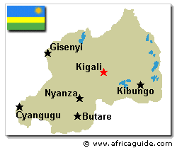 Introduction
Rwanda is a landlocked country surrounded by Uganda in the north, Tanzania in the east, Burundi in the south, and Zaire to its west and northwest.
Rwanda lies on the East African plateau, with the divide between the water systems of the Nile and Zaire rivers passing in a north-south direction through the western part of the country. To the west of the divide, the land drops sharply to Lake Kivu in the Great African Rift Valley; to the east, the land falls gradually across the central plateau - its grassy highlands are the core areas of settlement of Rwanda's population - to the swamps and lakes on the country's eastern border.
Most of Rwanda is 3,000 ft above sea level, with much of the central plateau being higher than 4,700 ft. In the northwest, on the border with Zaire, are the volcanic Virunga Mountains; the highest peak, Mount Karisimbi (14,870 ft) is snowcapped. Lake Kivu, 4,700 feet above sea level, drains into Lake Tanganyika, through the sharply descending Ruzizi River. The Kagera River, which forms much of Rwanda's eastern border, flows into Lake Victoria.
| Africa Guide's recommended book | ||
 | Rwanda, 3rd: The Bradt Travel Guide- by Philip Briggs (amazon.com) - USA (amazon.co.uk) - Europe As a guide to getting around Rwanda and seeing the beauty as well as the sorrow, the hope as well as the history, this is an important and timely book. It is packed with essential information for the traveller | |
| The Africa Guide's recommended Map | ||
 | Rwanda/Burundi Folded Map (Maps Worldwide) Published by ITMB Publishing Ltd Subtitle International Travel Maps specialise in areas that are interesting, exotic and off the beaten track. | |
Sudan
| |
 Introduction
Situated in northeast Africa, the Sudan borders with Egypt to the north, Ethiopia and Eritrea to the southeast, Kenya, Uganda and Zaire to the south, the Central Africa Republic and Chad to the west and Libya to the northwest.
The greatest part of Sudan is vast plain traversed by the northward flowing Nile River and its tributaries. Widely separated mountain chains and many hilly areas reach a maximum altitude of 7,000ft. The northern area is mainly desert, with rock at or near the surface covered by thin soils of low fertility. The western undulating sandy wastes merge into the Red Sea Hills to the east.
The dominating geographical feature of Sudan is the Nile River, formed near Khartoum by the confluence of the Blue Nile and White Nile Rivers. There are natural harbours at Port Sudan and Sawakin on the Red Sea. The highest elevations are in the Marra Mountains, the main mountain range.
Lowest Point: Red Sea 0m
Highest Point: Kinyeti 3,187m
| The Africa Guide's recommended Book | ||
 | Sudan: The Bradt Travel Guide (amazon.com) - USA (amazon.co.uk) - Europe Sthe first comprehensive guide to Sudan, that beyond troubled Darfur lies an extraordinary country, and a culture of kindness to strangers. Discover the archaeological riches of Kush and Nubia, scuba dive in the Red Sea, or relax on a Nile cruise through colorful Khartoum. | |
| The Africa Guide's recommended Map | |||||||||||||||||||||||||||||
 | Sudan Map by ITMB (Travel Reference Map) (amazon.com) - USA (amazon.co.uk) - Europe Distinguishes roads ranging from primary roads to other roads/tracks. Legend includes international/provincial boundaries, railroads, ferry lines, water/wells, dunes, international/national airports, airfields (small crafts), ports, gas stations, border crossings, points of interest, museums, archeological sites, wildlife reserves, nature reserves, missions/churches, mosques, campsites/huts, hotels, rest houses, hostels, oasis, diving sites, passes, coral reefs, National Parks. Includes inset of Khartoum. ============================ Tanzania Introduction IntroductionSituated in East Africa, just south of the equator, mainland Tanzania lies between the area of the great lakes; Victoria, Tanganyika and Malawi - with the Indian Ocean on its' coastline to the east. It has land borders with Uganda and Kenya to the north, Mozambique and Malawi to the south, Zambia to the southwest and Dem. Rep. of Congo, Burundi and Rwanda to the west. The country lies at an altitude of over 1,000ft, apart from a coastal strip varying in width from 10 to 40 miles. The greater part of the country is made up of plateau averaging 3,000 to 4,500ft in height. Mountains are grouped in various section. The Pare and Usambara ranges are in the northeast and the Livingstone Mountains in the southwest. Kilimanjaro (19,336ft) in the north is the highest mountain in Africa. On the borders are three large lakes; Victoria, the second-largest freshwater lake in the world, Tanganyika, second only to Lake Baykal as the deepest in the world; and Lake Malawi. Lakes within Tanzania include Natron, Eyasi, Manyara and Rukwa. Even though three great African rivers; the Nile, the Zaire and the Zambezi, have their origins in Tanzania, the country has few permanent rivers. During half the year, the central plateau has no running water, but in the rainy season flooding presents a problem. Lowest Point: Indian Ocean 0m Highest Point: Kilimanjaro 5,895m Tanzania can truly claim to be the home of "Safari" since the word is Kiswahili for "journey." And there's no better place to enjoy the enriching wildlife experience than Tanzania. The wildlife viewing experiences are widely regarded as the best in Africa. It's the place to see seemingly endless herds of wildebeest and zebras trekking across the plains on their annual migration, followed by the predators; lion, cheetah and hyena. Tanzania also lays claim to the title, "The Cradle of Mankind", as the remains of one of the earliest humans were discovered near Olduvai Gorge. And the visitor will want to see Ngorongoro Crater, the largest caldera in the world teeming with wildlife, along with the majestic, snow-capped Mount Kilimanjaro, is the tallest mountain in Africa. Tanzania also has hundreds of miles of palm-fringed beaches; lakes that are huge and bountiful with fish; relaxed and friendly cities; and exotic islands – Zanzibar, Pemba and Mafia. . Tanzania has something to offer for everyone, whether it be wildlife viewing, adventure, African culture or simply relaxing on the beach Click for Information about Zanzibar
Uganda
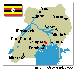 Introduction IntroductionUganda is located in east-central Africa, situated north and northwest of Lake Victoria. It is a landlocked country bordered by Sudan on the North, Kenya on the east, Tanzania on the South, Rwanda on the southwest and Zaire on the northwest. The greater part of Uganda consists of a plateau about 4,000 ft in height. Along the western border of the Ruwenzori Mountains reaching heights of over 16,000 ft, while on the eastern frontier Mount Elgon rises to 14,178 ft. By contrast, the Western Rift Valley, which runs from north to south through the western half of the country, is as low as 3,000 ft on the floor of Lake Edward and Lake George and 2,000 ft on the flow of Lake Albert. The White Nile River has its source in Lake Victoria.
| ||||||||||||||||||||||||||||


ليست هناك تعليقات:
إرسال تعليق